Mobile +484-548-3350

Mobile +484-548-3350

  • Home
  • Donation
  • Sidon Evidence
  • Magnetometry Report
  • Zarahemla Location
  • Ancient Languages
  • Ancient Medicine
  • Chief Keokuk
  • Reports from Ohio
  • Following Path 2
  • Evidence of Zarahemla
  • November Expedition 2021
  • Privacy Notices
  • One Square for Zarahemla
  • Book of Mormon Conference
  • Defensive Berms on Bluff
  • Zarahemla Centric Model
  • Scanning River Sidon
  • Radiocarbon Dating
  • Artifact LDS 60-5600
  • Technologies from Russia
  • PHOENICIA DINNER
  • More
    • Home
    • Donation
    • Sidon Evidence
    • Magnetometry Report
    • Zarahemla Location
    • Ancient Languages
    • Ancient Medicine
    • Chief Keokuk
    • Reports from Ohio
    • Following Path 2
    • Evidence of Zarahemla
    • November Expedition 2021
    • Privacy Notices
    • One Square for Zarahemla
    • Book of Mormon Conference
    • Defensive Berms on Bluff
    • Zarahemla Centric Model
    • Scanning River Sidon
    • Radiocarbon Dating
    • Artifact LDS 60-5600
    • Technologies from Russia
    • PHOENICIA DINNER
  • Home
  • Donation
  • Sidon Evidence
  • Magnetometry Report
  • Zarahemla Location
  • Ancient Languages
  • Ancient Medicine
  • Chief Keokuk
  • Reports from Ohio
  • Following Path 2
  • Evidence of Zarahemla
  • November Expedition 2021
  • Privacy Notices
  • One Square for Zarahemla
  • Book of Mormon Conference
  • Defensive Berms on Bluff
  • Zarahemla Centric Model
  • Scanning River Sidon
  • Radiocarbon Dating
  • Artifact LDS 60-5600
  • Technologies from Russia
  • PHOENICIA DINNER

let's find zarahemla

let's find zarahemlalet's find zarahemlalet's find zarahemla

North American Geography for Book of Mormon

North American Geography for Book of MormonNorth American Geography for Book of Mormon

Magnetic Signatures in Ground from Ancient Fires

Additional Information

First, we are looking for Zarahemla. That is a clear statement required for a thesis. Nothing wrong here. Second, we know where to look. We are looking at the site that Joseph Smith identified as Zarahemla. This then is the test of that hypothesis. Nothing wrong with that approach. We are looking for a confirmation of the truth of Joseph Smith's statement. Our methods are clear. We know that ancient people kept fires to cook their food, to heat their homes and to bring light to dark places. We know that the heat from these fires changed the magnetic signatures of soil and rock. These changes can be measured with a magnetometer. The SENSYS equipment can survey 100 acres per day within grids that are 1/4" x 1/4". Each data point will have GPS coordinates and will measure differences in magnetic forces by +/- 1nT (nanotesla). These readings will be able to identify the location of old fire pits.


The Book of Mormon informs us that in AD 320 there was a Nephite army from the Land of Zarahemla that had 30,000 men. Taking that number as our best indicator, we estimate that the population of Zarahemla was at least 100,000 people. We can find fire pits. We believe that there should be one fire pit for every 10 people or that within a mile or so of the city's center there would have been 10,000 fire pits. We know that German technology has worked very well on several sites including Stonehenge. We have our own experience with SENSYS from the mounds of Ohio. If we can find anything, we can find fire pits that were kept 1,600 years ago. I like science and I am willing to pay for it. If you can make improvements to our research, I welcome your informed opinion and not just off the cuff speculations. We expect that God's ancient promises will be fulfilled -- "the truth shall spring out of the earth".

2,000-year-old, 64-ft Diameter, Round House.  Post holes and fire pits

2,000-year-old, 64-ft Diameter, Round House.  Post holes and fire pits. Glenford, Ohio.

Ancient Novgorod and Zarahemla

Check out this great video

How Novgorod's Discovery Gives a Pattern for Finding Zarahem

Check out this great video

Heat from Fire Changes Magnetic Properties


Defensive Mounds South of Zarahemla

Location of Zarahemla

That Great City

The narrative of the Book of Mormon is set in time and place.  The book tells the story of Lehi's family, who left Jerusalem to America before the destruction of the First Temple.  In their new world, the descendants of these ancient immigrants grew and prospered for 1,000 years.


The book has a total of 6,000 verses, of which 500 refer to geography. The book has much to say about time and place for these people who lived from 600 BC to AD 421.  In more than 500 pages, there are more than 500 different place names.  In these pages, no other place-name is more frequent than Zarahemla.  That place-name is in 72 verses.  Just as Jerusalem is the great city of the Bible, so Zarahemla is the great city of the Book of Mormon.  Zarahemla is an ancient city that has exact points in the world's timeline.  Until now, no one has known for sure the details of its geographical settings.  Our goal is to correct this situation.  There is no history for any city without time.  There is no history of any city without place.  A city that lacks a position in time and a sense of place is inauthentic.  We desire to give exact coordinates in time and place for Zarahemla.  We intend to use the tools of modern science to discover the location of this city.  Taking the Book of Mormon as our guide, we seek to define coordinates for that great city Zarahemla.


The first research goal is to do SENSYS scanning on the site, which Wayne May has identified as the location for the Zarahemla Temple.


The second research goal is to locate the city wall for Zarahemla.  After we have done that, we will look within the limits of that wall for evidence of human habitation.


The third research goal is to find a layer of ash uniformly distributed at certain levels in the ground.  By using the science of radiocarbon dating, we expect to establish that the ash is from the burning of Zarahemla on Passover Day in AD 33.


As new goals, we will seek to confirm the re-building of Zarahemla in the 1st Century and the city's destruction and occupation by war in AD 335. Zarahemla was in a territory where there were more than a hundred million acres.  When looking for the lost city, one needs to make a hypothesis for the selection of a place where the search can begin.  We will start SENSYS scanning on the west side of the Mississippi directly across from Nauvoo.  Wayne May has spent years working on these sites.  We refer the reader to several YouTube videos where Wayne May explains the reasons for his selection of this site. 

Zarahemla and Des Moines Rapids

Upper Mississippi River

The proposed location for the scanning of Zarahemla is on a bend in the Upper Mississippi River just before the Des Moines Rapids.  These rapids have had a profound impact on the transport of goods on the waters of the Upper Mississippi.  Limestone formations at the bottom of the river created rapids, which played an essential role in the decision to build-up the city 2,000 years ago.


In its natural state, before the construction of the Keokuk Dam in 1913, the Mississippi at Nauvoo widened from 2,500 feet to 4,500 feet, where it began its drop of 22 feet over 11 miles over shallow limestone rocks to the confluence with Des Moines River.  The existence of these rapids over hard limestones stopped river traffic during the dry season.  During low water, the transport of goods at the bend in the river required the unloading, the portaging, and the reloading of raw materials and foodstuffs.  Otherwise, the outcropping of limestone in the river would easily tear at the bottoms of vessels, which would cause them to sink.  The rocks were an obstacle to the movement of millions of tons of goods up and down the river.  Near the Des Moines Rapids on the Upper Mississippi, there are hundreds of mounds that indicate that Zarahemla could have been close.


The small oval on the map is a starting point for the discovery of the Lost City of Zarahemla.  In the 1st Century, the flood plain from Montrose to Fort Madison was critical for supplying fresh produce for the people of Zarahemla.  On that plain, there are 16,400 acres of fertile land bounded on the west by high bluffs.

Thank you, robert e. lee, for helping us

September 1837 Survey of Des Moines Rapids

Zarahemla : Fire AD 33 and War AD 335

Carbon Dating Determines Time

The photo shows men in the early 1900s busting down and destroying ancient earthworks in Chillicothe, Ohio.  From this site, there were small pieces of bark from a Black Locust Tree and certain artifacts.  One hundred years later, the radiocarbon dating of these fragments of tree bark fixed its age at AD 40.  In the chronology of the Book of Mormon, AD 33 has great significance.  These men are digging a site that is associated with the time of Christ's visit to America.


There are advanced technologies that measure and identify ancient features buried in the ground.  The techniques come from solid scientific principles.  The procedures have had great success in unearthing history in other parts of the world.  The most notable example is Stonehenge.  German engineers made magnetic scans of adjacent lands.  The scanning revealed features in the ground, which enlarged the world's understanding of that famous site.  This same German technology will search for the areas of the Book of Mormon.


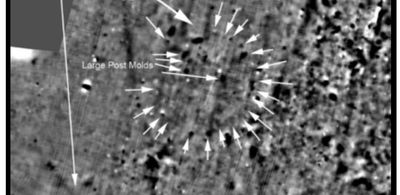
Cities are connected to vast landscapes.  SENSYS technology locates buried features from the activities of people who lived 2,000 years ago.  In December 2018 German technology found buried houses which are from the 1st Century.  On a hilltop in Ohio, the results of SENSYS surveys identified exact positions for more than a half dozen roundhouses.  Some roundhouses were large, with diameters of 64 feet.


SENSYS makes it possible to scan thousands of acres.  Each data reading has GPS coordinates which are within an accuracy of 1/4".  There are billions of data points.  The plotting of digital images from these points is the basis for discovering features for the lost city of Zarahemla.


We will make magnetic images from the data that come from the ground.  These digital images will locate ancient features in the cropland of Iowa.  The data plotted on digital maps, and from these images, we hope to identify and unearth the remains of Zarahemla.  We are looking for the foundations of a city wall.  Jerusalem in the 1st Century had a wall that was 12,000 feet in length. In that same century, the Roman city of London had a wall with a perimeter of 10,000 feet.  Ancient walls were expensive and gave important protection to the populations of cities.


 - Zarahemla was the city for the Nephite government that controlled a half million square miles of territory.  We expect to find traces of public buildings.


 - Zarahemla was a city of commerce and trade.  We expect to find roads and market places.


 - Zarahemla was a city of ritual and religion.  We expect to find traces of temples.


 - Zarahemla was a city of entertainment.  We expect to find places where ancient people gathered for public events.


 - Zarahemla was a city that was destroyed by fire on Passover in AD 33 and by war in AD 335.  We expect to find remnants of these destructions.

Destruction of 2,000-year-old mound in Chillicothe using mules, drag lines, and dirt scrapers.

Zarahemla of AD 330 Compared to Novgorod of AD 1200

An Alternative View - Ancient City Made of Earth and Wood

Zarahemla was an ancient city in North America.  Today no one knows the exact location of Zarahemla. Many imagine that the well-known, cities of the ancient world are models for the construction Zarahemla.  After all, so many of these cities were similar.  Stone was the typical building material for many places 2,000 years ago.  Some argue that if Zarahemla were a great city in history, the ancient people would have made it from stone, and that the remains would be impossible to hide from modern-day archaeologists.


Let us consider an alternative view for the construction of Zarahemla.  There are interesting points of comparison with the history of Novgorod of AD 1200 to the history of Zarahemla of AD 330.


The establishment of the great nation of Russia finds its roots in Novgorod.  In AD 1200 Novgorod was more important than Moscow.  It was a city not built of stone but of earth and wood.  Zarahemla in AD 330 was a city built mainly of earth, cement and wood.  Novgorod was the main city of a territory which had an area of about 500,000 square miles.  Zarahemla was the main city of a territory that had an area of about 500,000 square miles.  Novgorod was a city that via the Volga River connected to the heartland of Russia.  Zarahemla was on the Upper Mississippi that connected it to the heartland of America.  Novgorod resisted the Mongols, the Golden Horde of Asia.  Zarahemla resisted the Lamanites, the scourge of the Nephites.


Here are some comments about the two cities.


(1) Novgorod:  The city is one of the most intensively and continuously studied urban sites in northern Europe.  Systematic excavations began in 1932 and have continued almost every year since.  The excellent preservation of organic and inorganic material in its anaerobic soils, including the structural remains of streets, properties, and buildings, has made it possible to study entire quarters of the town as well as the activities of its inhabitants. With deposits, up to 24 feet deep in places, and with welldated sequences from the early to the mid-10th Century, its importance to the study of both medieval Russia and the development of Europe cannot be overemphasized. In addition, excavations have recovered many examples of the organic remains normally lost to archaeologists, including a stunning collection of birch bark letters, unique written documents of the medieval period, which now number over a thousand separate inscriptions. Because of this, the site has received attention from a wide range of scholars from differing fields including medieval archaeology, history, architecture, botany, zoology, and linguistics.


(2) Zarahemla:  The city is known in time but unknown in place.  Until now the only references to the city are found in the Book of Mormon.  It is time for modern technology to locate Zarahemla so that the dust may reveal the truth and the world may marvel at that city's rich history.

Novgorod made of wood and earth.  Russia's greatest city 1,000 years ago connected to the Volga.

11th Century Novgorod Comparable to 4th Century Zarahemla

Large River Basins and World Trade

Large River Basins and World Trade

Large River Basins and World Trade

Nicholas Roerich: Through a Portage (1915)


The painting shows Viking ships carried over land to make the connection from the waterways of northern Europe to the headwaters of the Volga River.  From Aldeigjuborg, the Rus traveled up the Volkhov River to Novgorod, then to Lake Ilmen and further along the Lovat River. Taking their boats 2 miles over a portage, they reached the sources of Volga River.


Russia's most famous waterway, the Volga River, connects to the great city of Novgorod. Novgorod was the largest city in Russia from the 9th to the 11th Centuries.


North America's most famous waterway, the Mississippi River, connects to the great city of Zarahemla. Zarahemla was the largest city in North America from the 1st to the 4th Centuries.


Novgorod one thousand years ago and Zarahemla two thousand years ago were great cities built from earth and wood.  The remains of these two cities are found buried in the ground.

Novgorod Connection to Volga River

Large River Basins and World Trade

Large River Basins and World Trade

In the Middle Ages, the Volga trade route connected Northern Europe and Northwestern Russia with the Caspian Sea and the Sasanian Empire, via the Volga River. The Rus used this route to trade with Muslim countries on the southern shores of the Caspian Sea, sometimes penetrating as far as Baghdad. The powerful Volga Bulgars (cousins of todays Balkan Bulgarians) formed a seminomadic confederation and traded through the Volga river with Viking people of Rus' and Scandinavia (Swedes, Danes, Norwegians) and with the southern Byzantine Empire (Eastern Roman Empire)  Furthermore Volga Bulgaria, with its two cities Bulgar and Suvar east of what is today Moscow, traded with Russians and the fur-selling Ugrians. Chess was introduced to Old Russia via the Caspian-Volga trade routes from Persia and Arabic lands

Zarahemla Report May 2019

Zarahemla Text and Figures 16 Pages (pdf)

Download

The Chief and the prophet

Check out this great video

Photo Gallery


Copyright © 2023 Zarahemla - All Rights Reserved.

Powered by GoDaddy Website Builder

This website uses cookies.

We use cookies to analyze website traffic and optimize your website experience. By accepting our use of cookies, your data will be aggregated with all other user data.

Accept

New Website Live!

Try the new site for the latest news... 

zarahemlasite.com